Mines researcher part of NASA-selected satellite mission
Satellite measuring land, polar and coastal regions could launch as soon as 2030
A Colorado School of Mines professor is part of an international research team selected by NASA for a satellite mission for the Earth System Explorers (ESE) program.
The Earth Dynamics Geodetic Explorer (EDGE) mission led by the University of California San Diego is one of two next-generation satellite missions selected to help better understand Earth systems and improve capabilities to foresee environmental events and mitigate disasters. These missions were selected from a set of four that were announced as finalists in May 2024.
Each mission will be subject to NASA confirmation review in 2027, which will assess the progress of the missions and the availability of funds. If confirmed, the total estimated cost of each mission, not including launch, will not exceed $355 million with a mission launch date of no earlier than 2030.
EDGE, the first global satellite imaging laser altimeter system, will substantially advance observations of land, vegetation, ice and coastal regions.

Matt Siegfried, associate professor of geophysics at Mines, is a co-investigator for the mission and a member of the EDGE science team, helping to design the data products for glaciers, ice sheets and permafrost. He will also lead the validation of the ice elevation data products, developing techniques for assessing uncertainty in what will likely be the most accurate spaceborne altimeter ever launched.
Laser altimetry is a technology that sends laser pulses to Earth’s surface and records the time it takes them to return to the spacecraft. Scientists measure how long it took the laser pulse to bounce back to measure the height and structure of Earth’s surface. This technology allows scientists to make high-resolution, three-dimensional observations of the structure of terrestrial ecosystems like forests and the surface features of glaciers, ice sheets and sea ice.
Capturing accurate data in these critical regions is crucial for greater understanding of the state of Earth’s systems, as well as supporting national security, global transportation, water resource planning, risk management and providing strategic environmental intelligence to policymakers.
“It’s astounding to get to this point after working on a mission concept for four years. NASA missions are exactly where top-end engineering and science intersect, and I’m thrilled to be able to bring the science and engineering mentality that we work so hard to develop across campus at Mines to the next generation of NASA’s Earth observing tools,” Siegfried said. “The fun part is pushing the boundaries of our science and engineering in the mission proposal. Now comes the hard part of putting that idea into space.”
The EDGE mission builds on heritage from GEDI and ICESat-2, led by NASA Goddard Space Flight Center; Siegfried currently serves as co-lead of the Land Ice Working Group of the ICESat-2 Science Team. NASA Goddard will also be the implementing center for EDGE.
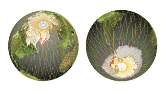
EDGE will be the first swath-mapping lidar in space with new technology that will have an increased density of laser beams that will map the planet using five 120-meter (400-feet) wide strips, the instrument on EDGE will provide much denser coverage as well as higher resolution and accuracy, enabling a more comprehensive view of the dynamics of the Earth’s surface. This unprecedented resolution of the depth, height and structure of terrestrial, polar and coastal systems will bring Earth’s features into focus to enable understanding of the processes driving change.
“I am so delighted to lead the EDGE mission, bringing together a cross-disciplinary team of scientists and engineers with a shared goal of developing a next-generation instrument to measure the vital signs of our planet in our most critical regions,” said lead investigator Helen Amanda Fricker, a glaciologist at the Scripps Institution of Oceanography at UCSD.
EDGE aims to expand global coverage of vegetation and dense mapping around the edges of ice sheets and sea ice packs, including Earth’s polar regions. To achieve this global coverage, along with the required pointing stability and agility, EDGE will fly on a Lanteris 500™ series spacecraft from Lanteris Space Systems, a wholly owned subsidiary of Intuitive Machines.
The EDGE team is composed of 25 scientists and engineers from around the world. In addition to Fricker, leadership includes deputy PI John Armston from the University of Maryland, and Instrument PI Bryan Blair and Project Scientist Scott Luthcke from NASA Goddard Space Flight Center. Scientists from the University of Maryland, U.S. Forest Service, George Mason University, Boise State University, U.S. Geological Survey, Bristol University, UCLA, National University of Singapore, and the Smithsonian Tropical Research Institution round out the team for terrestrial ecosystem structure, while the ice elevation team features scientists from the University of Washington, University at Buffalo, Colorado School of Mines, the Australian Antarctic Division and the University of Tasmania.
With this selection, the mission will advance to the next phase of development. Each mission will be subject to confirmation review in 2027, which will assess the progress of the missions and the availability of funds.
For more information about NASA’s Earth System Explorers Program, visit https://explorers.larc.nasa.gov/2023ESE/.

About Mines
Colorado School of Mines is a public R1 research university focused on applied science and engineering, producing the talent, knowledge and innovations to serve industry and benefit society – all to create a more prosperous future.