Ice-cored hills in the Arctic could help us detect water on other planets
Mines researchers partner with NASA to survey pingos in Canada’s Northwest Territories
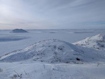
The Tuk peninsula in Canada is home to the greatest concentration of pingos — roughly 25 percent — on Earth. (Photo courtesy of Ben Hills)
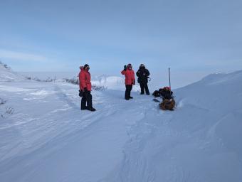
A Colorado School of Mines researcher recently spent almost two weeks surveying cone-shaped hills along the Arctic Ocean in Canada to see what they can tell us about other planets.
But instead of being comprised of dirt and rock, these hills are thought to be made of solid ice, and they’re called pingos.
But what is a pingo, exactly?
These permafrost ice-cored hills are found in the Arctic, subarctic – and even potentially on other planetary bodies like Mars and Ceres, the dwarf planet in orbit between Mars and Jupiter. There are roughly 11,000 pingos on Earth, a unique geological formation for which very little data currently exists.
Ben Hills, a postdoctoral researcher in the Mines Glaciology Lab, traveled to Tuktoyaktuk on the Arctic Ocean in Canada’s Northwest Territories to gather data on the life cycles of the pingo. The Tuk peninsula is home to the greatest concentration of pingos on Earth, roughly 25 percent. Tuk is located within the Arctic Circle – in fact, it is the northernmost town in Canada that you can drive to.
But what Hills and other researchers are really interested in is what these ice-cored hills could tell us about the landscape of other planets and even if these features may provide a mineable water resource for future human exploration.
Spacecraft observations have shown indisputable evidence of pingo-like features on Mars and Ceres. By studying the pingos closer to home, researchers hope to refine their surveying tools before sending them out into our solar system to detect and characterize ground ice and water.
“We can use these unique features on Earth to learn about other planets,” Hills said. “We want to do as much preparation for research in outer space using Earth’s environments as an analog to test our instruments before sending them on these far-off missions.”
Hills and the research team are studying hydrostatic or closed-system pingos. These types of pingos form as a result of pressure build-up within the pingo’s core. Tuk is a region of continuous permafrost – solid frozen sediment – whose ground layer is impermeable, which means water cannot pass through. Water collects under the sediment layer – often in the form of an infilled lake – and in the winter months when the sediment freezes and expands into the water, the pressure builds into a mound, or rather, a pingo.
Mines researchers are conducting tests on the pingos to map the ice and water below. They are surveying using three different approaches, all of which should produce an analysis at different depths.
First, electrical resistivity tests using near-surface instruments to examine the first five to 15 meters of the pingo. Second, radar tests to examine even further, hopefully up to 100 meters. And lastly, transient electromagnetics will ideally measure the entirety of the pingo, and hopefully hundreds of meters below.
“This is our third year heading up to the Arctic, with one season in Alaska and one season in Tuk,” said Matt Siegfried, assistant professor in the Department of Geophysics and the project lead at Mines. “We’ve worked out the kinks in all three observation approaches while collecting baseline data from pingos with a wide range of shapes and sizes. This year we can really dive in and understand the three-dimensional structure of these features from top to bottom.”
Hills is conducting the research as part of Pingo STARR (Pingo Subterranean Aquifer Reconnaissance and Reconstruction), a project funded by NASA’s PSTAR (Planetary Science and Technology through Analog Research) Program.
Leading the project are Britney Schmidt of Cornell University and Ky Hughson of University of New Brunswick, who are working alongside several Mines researchers including Hills, Matthew Siegfried, Andrei Swidinsky, and John Bradford. The project is the first dedicated analysis of pingos from a planetary science perspective.
Past research trips have proved successful in collecting near-surface data, so on this trip, the team is focused on radar and electromagnetic tests. To do this, they have developed new instruments and altered old ones.
Pingos started appearing on Earth after the last Ice Age as a result of the overall change in climate. Hills and other researchers worry that human-caused climate change could soon melt the permafrost that provides the necessary environment for these fascinating geological formations.